Safety in Numbers
Brighter Planet's blog
2010 on track for record high temps
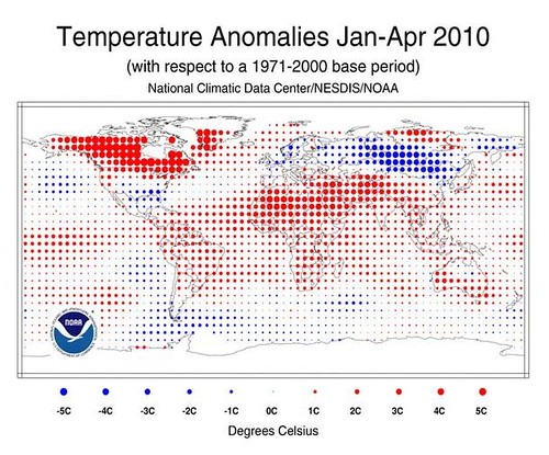
It’s that time of the month again – the week when NOAA scientists release last month’s “combined global surface temperature” data – and we’ve got yet another winner. It was the warmest April on record, hot on the tail of the warmest March.
The March and April heat was more than enough to pull the entire four-month January–April average into record territory, despite January and February having been merely the fourth- and sixth-warmest on record.
Yes, you’re reading that correctly: the North American Arctic has been about 9 DEGREES FARENHEIGHT (5 C) warmer than average these last four months. Yikes.
Expect to see more of the same as we move into the rest of 2010: NASA researchers predict the trend to continue, forecasting that 2010 will weigh in as warmest year in recorded history.
The effects? Well for one, warmer sea surface temperatures are a key element in predictions by folks at CSU, NCSU, and Accuweather that the 2010 Atlantic hurricane season (which opens on June 1) will be significantly more active than average and “has the chance to be an extreme season.” Critics have called the Gulf oil spill “Obama’s Katrina”, but chances appear better than average he’ll get a literal Katrina of his own.
–Matthew
What blog is this?
Safety in Numbers is Brighter Planet's blog about climate science, Ruby, Rails, data, transparency, and, well, us.
Who's behind this?
We're Brighter Planet, the world's leading computational sustainability platform.
